WIND METEOROLOGICAL FOR NAVIGATOR
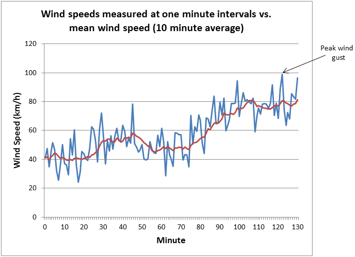
It is crucial that for the maritime navigator to know about the wind to order to navigate vessels. The wind is basically made up by guts and lulls. Base on the the report by the Bureau's forecasts the guts and lulls normally will be form up wind average due to their speed and direction, the wind usually will be measure at over-a 10 minute period at a height of 10 meters above seal level. For the guts will be 40% powerful than the average wind speed in any period of 10 minutes.
| (Source from Google image https://www.google.com/url?sa=i&source=images&cd=&ved=2ahUKEwjB9d_m5rvjAhX97XMBHQ-sCDMQjRx6BAgBEAU&url=http%3A%2F%2Fwww.bom.gov.au%2Fmarine%2Fknowledge-centre%2Freference%2Fwind.shtml&psig=AOvVaw1gyxIBM1dUSbXwsXzkdEJs&ust=1563447730069849) |
 |
| ( Source from Google image https://www.google.com/url?sa=i&source=images&cd=&ved=2ahUKEwiK_oGw5rvjAhWFNY8KHRwCBloQjRx6BAgBEAU&url=https%3A%2F%2Fblog.metservice.com%2FBeaufortWindScale&psig=AOvVaw1XHoUL19J08LFjWLvEulT5&ust=1563447602646811) |
The state of the wind are relative to the height above the sea surface, the higher of the sea surface the stronger of the wind you will face. The wind bulletin will only be announce when the speed of the wind are vary significantly close to coastal area. The true north pole are the base for all the wind direction and where the wind comes from.
For the Wind warnings and Guts
| Average wind speed (knots) | Gust strength that should be planned for (knots) | Wind Warning thresholds |
|---|---|---|
| 10 | 14 | |
| 15 | 21 | |
| 20 | 28 | |
| 26 | 36 | Strong wind warning issued |
| 34 | 48 | Gale force warning issued |
| 48 | 67 | Storm force warning issued |
| 64 | 90 | Hurricane force warning issued |
(Source From Google image)
Due respect on the above list, we will above to alert that the warnings of the particular wind having right now or will be engaging when we are navigate on the sea. The weather will be decide whether that is a need of alteration of the course apart from the origin planing, or neither to pick up the pilot during the pilotage if there situation does not allow we may be consider to anchor until the wind cease or turn to smaller.
Beaufort Wind Scale
The Beaufort wind scale measures wind speed according to the impact the wind has on the land and sea. It is an old reference we having to help us to categories the state of the wind. First developed in 1805 by Sir Francis Beaufort for your information.
Last of all, I would like to express my gratitude to this website (http://www.bom.gov.au/?ref=logo) for provide the information and knowledge. Hence that I could be sharing to you guys.
 |
| (Source From Google image https://www.google.com/url?sa=i&source=images&cd=&ved=2ahUKEwi4nr6h57vjAhUF73MBHeItDTIQjRx6BAgBEAU&url=http%3A%2F%2Frizneyland.blogspot.com%2F2015%2F06%2F&psig=AOvVaw0pLUwGE_DxMRxpDfRnJcRw&ust=1563447833342523) |
Last of all, I would like to express my gratitude to this website (http://www.bom.gov.au/?ref=logo) for provide the information and knowledge. Hence that I could be sharing to you guys.
No comments:
Post a Comment